Cold front brings storms and damaging winds through North Texas, before the weekend dries out
A cold front moved into North Texas Friday evening, bringing showers and thunderstorms, and even a couple of severe thunderstorms right during Friday evening football games. Strong, damaging winds moved through parts of the metroplex as evening games and activities let out.
This storm activity is, in part, associated with a cold front moving through North Texas, which will continue to track southeast into the overnight hours.
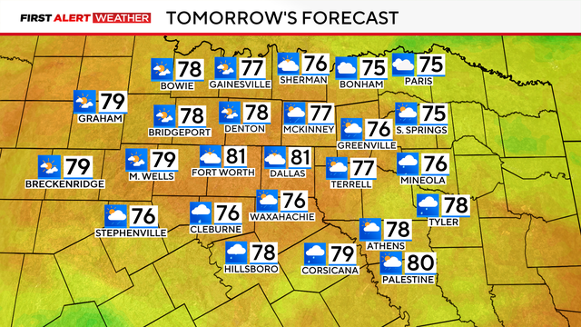
Weekend Forecast rain chances
Fortunately, most of that shower activity looks to clear up Saturday morning.
Rain chances for the rest of the weekend will remain fairly isolated in nature, and mainly look to stick south of I-20. The weekend is far from a washout, we will just be much cooler.
Expect highs in the upper 70s to near 80 on Saturday.
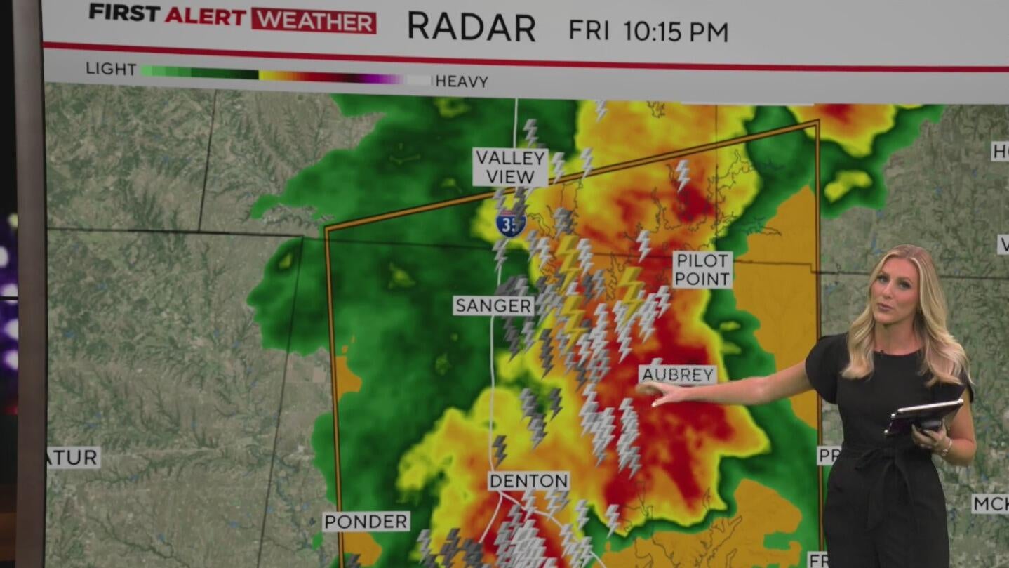
Friday evening storms
At 11:12 p.m. Friday, severe thunderstorms were located along a line extending from Richardson to Hutchins and moving east at 25 mph. Dallas continues to see these strong winds move through the area with winds up to 60 mph. Winds moving at 55 mph have been detected at Dallas Love Field, where there are flight delays of over an hour.
A Severe Thunderstorm Warning has been issued for Dallas County for strong, damaging winds that could reach around 60 mph until 11:30 p.m. Friday. This includes Dallas, Garland, Irving, Grand Prairie, Mesquite, Carrollton, Richardson, Rowlett, Desoto, Grapevine, Cedar Hill, Wylie, Coppell, Duncanville, Lancaster, Farmers Branch, Balch Springs, University Park, Sachse, and Seagoville. The main threat is the strong winds that could knock down trees and power lines. Small hail is also possible.
The Severe Thunderstorm Warning remains in effect for eastern Denton, Collin and southeastern Grayson Counties until 11:30 p.m. Friday.
As of 10:40 pm, 60 mph wind gusts were seen around Lewisville with storms moving to the east and into Collin County. Wind speeds of 40mph are being felt near Dallas and Tarrant Counties.
As of 9:55 p.m., a severe thunderstorm warning has been issued for parts of Denton County, including Denton, Little Elm, and Corinth, until 8:45 p.m., according to the National Weather Service.
As of 9 p.m., a Severe Thunderstorm Warning was in effect for areas including Paris, Reno, and Honey Grove until 10 p.m. The National Weather Service warned of potentially damaging winds, hail, and frequent lightning as the storm moved through the region.
As of 8 p.m., a strong thunderstorm was expected to impact portions of northwestern Hunt, northern Collin, southeastern Grayson, and western Fannin counties. The National Weather Service warned of potential severe conditions as the storm moved through the area.
Storms interrupt Friday night football in North Texas
As of 7:35 p.m., thousands of customers in North Texas were without power following severe weather. In Collin County, 5,475 of 508,960 tracked meters (1.08%) experienced outages. In Denton County, 7,150 of 519,531 tracked meters (1.38%) were without electricity.
As of 7:32 p.m., the National Weather Service reported that a storm in Collin County continued to pose a threat of wind and hail. The strongest part of the storm was located between Celina and Weston, moving east-northeast. Winds could reach up to 60 mph, and hail larger than one inch in diameter was possible in that part of the county.
As of 7:23 p.m., a severe thunderstorm near Prosper was moving east at 40 mph, producing quarter to half-dollar-sized hail. The warning remains in effect until 7:45 p.m. for eastern Denton and western Collin counties.
After 7 p.m., a ground stop was issued at Dallas Fort Worth Airport due to severe weather conditions.