Nor'easter barreling toward NYC this weekend. Here's what to expect.
We're gearing up for a round of wet weather in and around NYC, as a nor'easter takes aim at the East Coast this holiday weekend.
Watch CBS News

We're gearing up for a round of wet weather in and around NYC, as a nor'easter takes aim at the East Coast this holiday weekend.
The bulk of the rain looks to be Thursday, which is why we have declared a First Alert Weather Day.
Grab the umbrella before you leave the house today, because rounds of rain are possible off and on throughout the day.
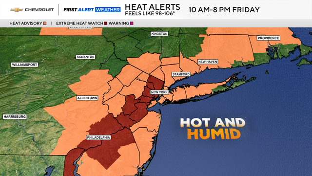
The heat and humidity build Thursday into Friday, and some areas could flirt with heat warning criteria by Friday afternoon.

The potential of strong to severe storms on Thursday has prompted a First Alert Weather Day.

A First Alert Weather Day is in effect on Wednesday due to the slight risk of severe storms.
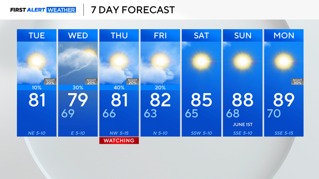
There is a chance for spotty storms and showers Wednesday.

Memorial Day weekend in North Texas is starting out clear and sunny, but storms are on the way and will hamper plans on Monday.
Thursday is a First Alert Weather Day for the potential of strong to severe storms in the afternoon and evening hours.

Memorial Day weekend could be rainy.

A First Alert Weather Day remains in place Wednesday due to the dangerous heat.

A heat wave is on the way.

As the upper-level low pressure to the east moves further east, a ridge of high pressure will build into the Southern Plains, and that will start to bake North Texas mid-week.

By the middle of May, spring storms are expected to return.
The main threats with Tuesday's storms include wind damage, large hail and flooding.