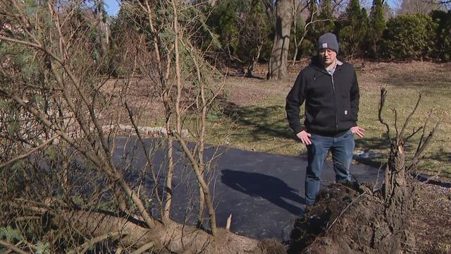
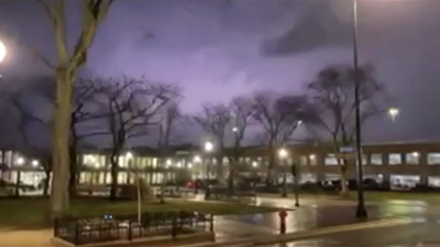
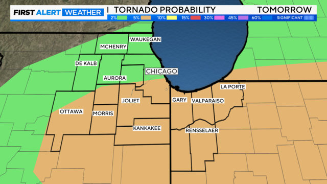
Storms, possible tornadoes wallop Chicago's northwest suburbs
Neighbors reported seeing funnel clouds and extensive damage, including lost power which was restored as of Wednesday.
Watch CBS News
Meteorologist Mary Kay Kleist has been a fixture on CBS News Chicago since 2002.
Since joining the station, Kleist became a Certified Broadcast Meteorologist (2007), which is the industry's highest distinction. In addition to earning several local Emmy Awards at CBS News Chicago – including three Emmy Awards in 2015 for coverage of the April tornadoes, a severe weather special and best on-camera weather anchor – Kleist has been awarded an AMS Seal of Approval and an NWA Broadcasting Seal of Approval.
Kleist has been a meteorologist for print, radio and television broadcasts for more than 25 years. She first worked in Chicago from 1994-95 as a weather anchor for WGN-AM Radio and CLTV. However, she joined CBS2 Chicago from WXYZ-TV in Detroit, Michigan, where she had worked as a meteorologist since 1999, reporting weather for the station's weekend newscasts.
Prior to her work at WXYZ-TV, Kleist worked in Tampa, Florida (1995-99), as the meteorologist for WFLA-TV. There, she also reported the weather for The Tampa Tribune, the local edition of CNN Headline News and served as weather anchor at WFLA-AM Radio.
Kleist began her career at WJCL-TV in Savannah, Georgia (1992-94), where she worked as the weekend weather anchor, a health and general assignment reporter, news anchor, photographer, editor, as well as anchor of the local edition of CNN Headline News.
Kleist graduated Magna Cum Laude from the University of Central Florida in 1992 with a B.A. in Radio and Television, and later graduated from the Broadcast Meteorology Program at Mississippi State University.
Neighbors reported seeing funnel clouds and extensive damage, including lost power which was restored as of Wednesday.
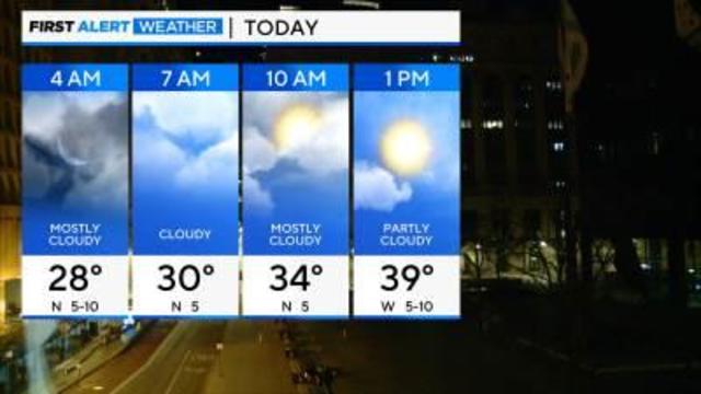
On Wednesday morning, the wind chill will be in the single digits in some parts of the area.
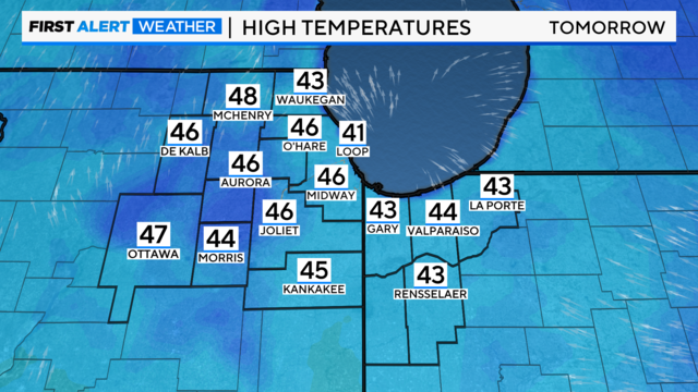
Temperatures will crash behind the front leaving snow showers and blustery conditions for Wednesday.
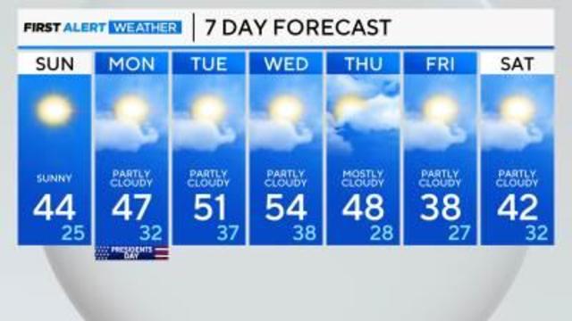
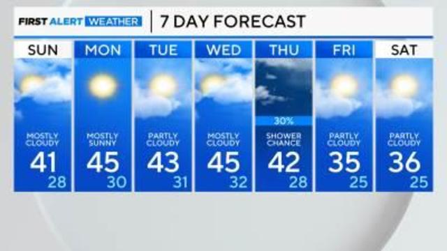
Clearing for Saturday and colder with highs in the mid-30s but on Sunday we jump 20 degrees warmer!
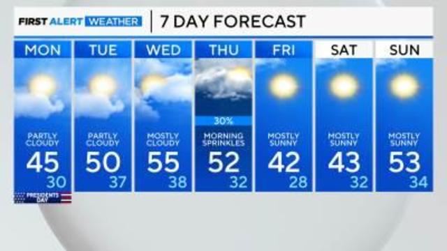
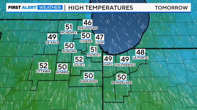
A gradual warming trend is on the way, especially Tuesday through Thursday, with highs reaching the 50s.
A warming trend begins with highs reaching to mid-50s by Wednesday.
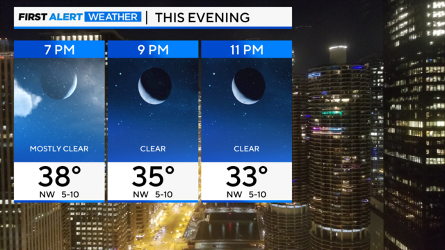
Wind chills will dip into the teens.
A colder air mass moves in starting Friday with gusty northwest winds and passing flurries.
Temperatures will again be above average with highs in the lower 40s.
Clouds will increase in the Chicago area overnight Saturday and linger Sunday morning.
High pressure keeps conditions dry & quiet this weekend, just in case you host an outdoor Super Bowl party.
Northwest flow takes over ushering in a cooler air mass for Saturday and Sunday.
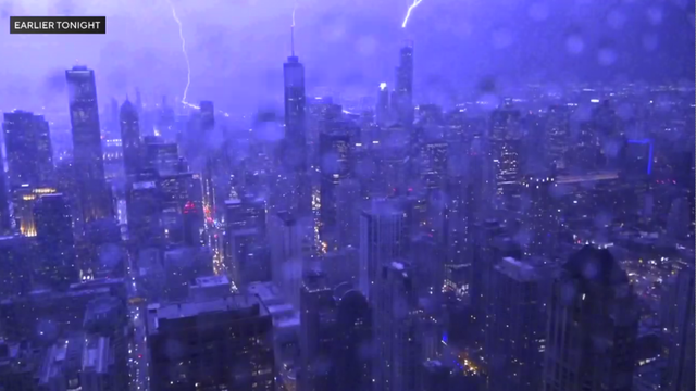
Damaging winds also blew late Thursday.
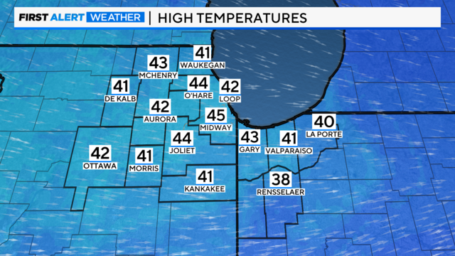
The normal high is 33 degrees.
With the mild air in place at the end of the workweek, the next disturbance will be all rain.