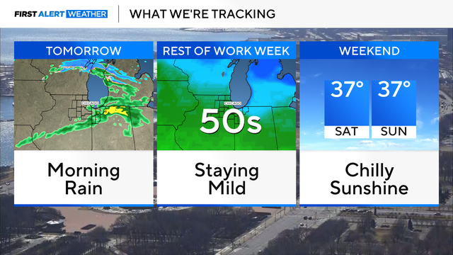
Warming trend continues for Chicago this week, with rain on Wednesday
Temperatures remain very mild throughout the work-week with highs in the 50s and 40s.
Watch CBS News
Meteorologist Kylee Miller is designated as a Certified Broadcast Meteorologist and a Certified Digital Meteorologist by the American Meteorological Society.
Growing up in Michigan, Kylee attended Early College Alliance at Eastern Michigan University for her junior and senior years of high school, earning an associate degree during that time.
She then pursued meteorology at Central Michigan University, graduating with a bachelor's degree in meteorology, a minor in math, and an emphasis in broadcasting.
Kylee is an Emmy Award-winning meteorologist by the Regional Southeast Emmy Chapter, covering "Tornado Aftermath," and was Emmy-nominated for covering "Deadly Flooding Aftermath" in the Carolinas. In 2024, she was honored at CMU with the 10 within 10 alumni award which recognizes exceptional achievements after graduation. She also received the Midwest Communications, Inc. broadcasting scholarship through the Michigan Association of Broadcasters.
Kylee joins the First Alert Weather team at CBS Chicago from CBS Detroit. She has also worked at Fox Carolina, Saginaw/Flint, Lansing, and WeatherNation with national and Caribbean experience. While Kylee has forecasted all different weather types, she has also taught meteorology courses at Eastern Michigan University and has been featured at CMU and EMU, helping promote the weather curricula.
In Kylee's spare time, she enjoys working out, shopping, boating, spending time with family and friends, watching all her favorite sports teams, storm chasing, and forecasting weather! Catch Meteorologist Kylee Miller's forecast on CBS News Chicago, and you can follow Kylee on Facebook, X, and Instagram.
Temperatures remain very mild throughout the work-week with highs in the 50s and 40s.
Throughout the rest of the workweek, highs will be approaching the upper 40s and lower 50s.
With these mild temperatures, expect the snowpack to continue to melt away.
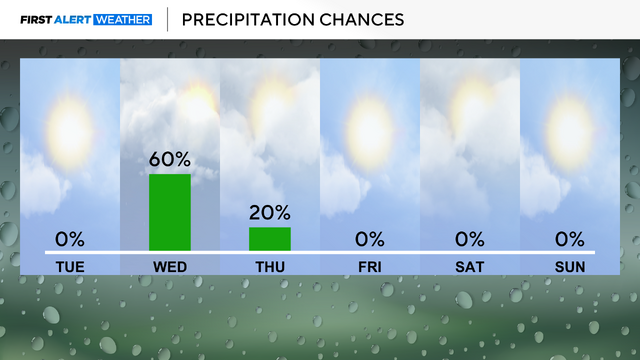
High temperatures will stay in the 40s for highs for much of the week, with some opportunities for rain shower activity.
Bitterly cold conditions are in place again Tuesday morning.
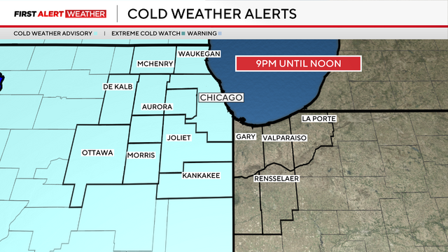
Actual air temperatures will fall below zero Monday night.
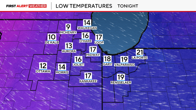
Lows were dropping toward zero degrees, and factoring in the brisk winds will make it feel like -15 to -25 degrees outside.
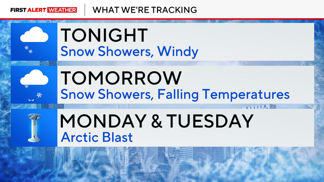
Monday and Tuesday will be the coldest days, with dangerously cold wind chill readings in the -15 to -25 degree range.
Snowfall reports as of 9 p.m. range from 1.5" to 4".
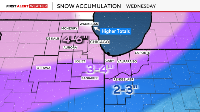
Widespread snowfall totaling 4 to 6 inches is expected through Wednesday, with isolated higher amounts along the North Shore.
A snowstorm Wednesday into Thursday looks to have a lot of moisture associated with it, meaning at least a few inches of accumulating snow right now is looking more likely.
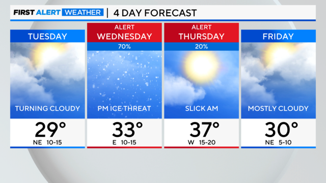
By midday, ice will thaw as temperatures rise to around 40 degrees.
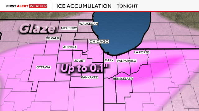
Widespread freezing rain and drizzle are causing untreated roads, sidewalks, and driveways to become icy and slick.
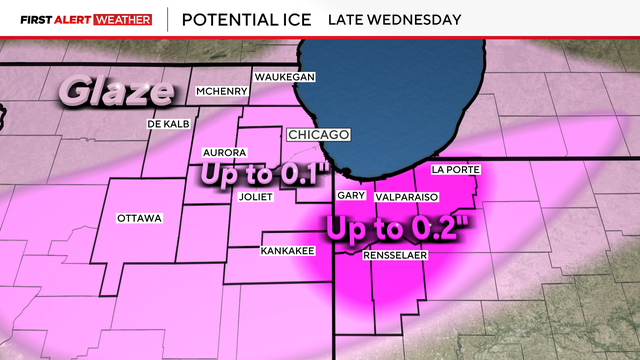
Light snow showers begin Wednesday morning, turning to a freezing rain threat by evening and into the night.
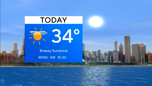
Monday's highs will reach close to 50 degrees.