
Pleasant Friday in Twin Cities, winter storm warning in Arrowhead
The Twin Cities will enjoy more sunshine on Friday with temps 10-15 degrees cooler than Thursday's record highs.
Watch CBS News

The Twin Cities will enjoy more sunshine on Friday with temps 10-15 degrees cooler than Thursday's record highs.

The Twin Cities are enjoying record-breaking warmth on Thursday, but a cooldown is right around the corner.
Tuesday will be breezy and warm with clearing clouds in the Twin Cities.

The Twin Cities will get a break from winter to start the week, with highs close to 40 degrees on Monday.
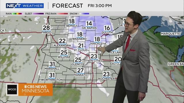
Warmer air is expected to make its return on Friday, along with some light snow in the afternoon.

Thursday will be another frigid one in the Twin Cities, but a weekend warm-up fast approaches.
After a string of frigid days, temperatures will climb into the upper 20s in the Twin Cities on Wednesday.

Things are warming up a bit in Minnesota following an extremely frigid morning.

A NEXT Weather Alert is in effect Monday as dangerous cold assaults Minnesota.

Minnesotans have one more day to enjoy the January thaw before the return of dangerous cold.

The week will wrap up with two mild days, but over the weekend highs will take a hit.
Wednesday begins an ascent to warmer days in the Twin Cities, but another harsh drop is ahead.
We will see some sunshine, but feels-like temperatures will be in the negatives.

Highs across the state will be in the single digits, and even colder in spots.

Aside from some flurries on Friday morning, it's a fairly quiet end to the week in the Twin Cities with a mostly cloudy sky.