
Rain possible in spots Tuesday ahead of midweek warm-up
A warming trend begins Wednesday that will bring temperatures into the 60s by Thursday, and the 70s by Friday in parts of Minnesota.
Watch CBS News

A warming trend begins Wednesday that will bring temperatures into the 60s by Thursday, and the 70s by Friday in parts of Minnesota.

After a chilly weekend, it will feel more like spring in Minnesota this week.

A cold front may bring isolated showers to the Twin Cities on Friday, followed by a brief temperature drop before rebounding into the 40s and 50s by Saturday afternoon.

The Twin Cities will enjoy a mild first day of spring on Thursday before a weekend cooldown and Sunday storm.

The trajectory of a spring snowstorm headed for Minnesota shifted overnight, leaving the Twin Cities free and clear. Southern Minnesota, however, could still see blizzard conditions.
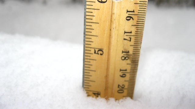
The next spring snowstorm is heading to Minnesota on Wednesday. Here's the latest look at potential snowfall totals.

Weather conditions will shift in the Twin Cities on Tuesday as a cold front moves in and the next storm system approaches.

The Twin Cities will have a tranquil and warm start to the week, but a disruptive storm will arrive Tuesday night.

Thursday will be another gorgeous one in the Twin Cities, but the threat of severe weather looms for Friday and Saturday.
Highs will rise to the 50s on Wednesday as part of a gradual warming trend that will bring the Twin Cities into the 70s by the end of the week.

After several spots in Minnesota saw record warmth on Monday, Tuesday's forecast may be a bit of a letdown.
Monday is bringing both record-breaking heat and an elevated fire risk to Minnesota and western Wisconsin.

The Twin Cities can expect strong winds on Friday, a chilly Saturday and a potential midweek storm.

The Twin Cities will enjoy a quiet Thursday before strong winds arrive on Friday, and temperatures fall this weekend.
Things will stay mild in the Twin Cities on Wednesday, with highs approaching 50 degrees.