
Sunny conditions Saturday prompt Top 10 Weather Day; rain returns Sunday
Friday will be a classic fall day in the Twin Cities with sunshine, a light northwest breeze and comfortable highs in the mid-to-upper 60s under clear skies.
Watch CBS News

Friday will be a classic fall day in the Twin Cities with sunshine, a light northwest breeze and comfortable highs in the mid-to-upper 60s under clear skies.

Clouds increase Thursday afternoon in the Twin Cities, with a few showers possible in the evening hours.

Minnesota is dealing with more warmth and strong winds ahead of a cold front set to pass through Sunday afternoon.

With mainly sunny conditions across the region on Saturday and winds coming from the south, expect more unseasonably warm temperatures to start the weekend.

Trollhaugen in Dresser, Wisconsin, piled up a bunch of the white stuff back in March in hopes of using it for their 20th anniversary Rail Jam this weekend.

A new National Oceanic and Atmospheric Administration satellite is on its way to space after launching from Kennedy Space Center Wednesday morning.

Minnesota's stormy stretch is just about done, making for a mostly dry Sunday for much of the state.

The slow-moving storm system that has been over the region the past few days will continue to provide clouds and fog Saturday morning.

Storm chances linger on Thursday in the Twin Cities, with rounds of heavy rain possible into the weekend.
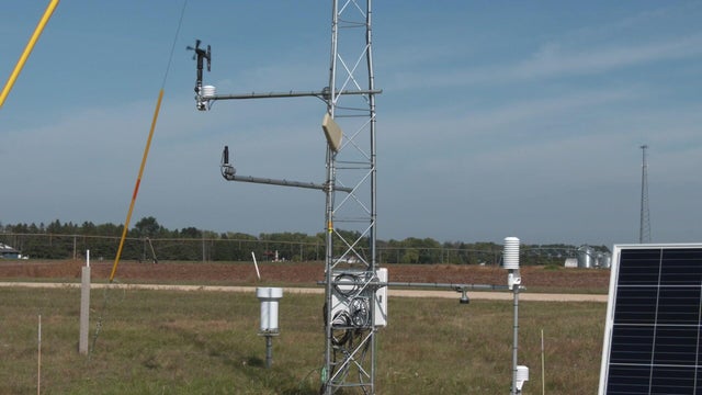
"We're measuring everything between 33 feet above the ground surface to 7 feet below the ground surface," said Jeppe Kjaersgaard, a research scientist with the Minnesota Department of Agriculture.

A few isolated storms will fire later Sunday evening across western Minnesota. Some storms could make it east toward the Twin Cities by dawn.

Thanks to a stalled storm system to our west and southerly winds, high temperatures will be in the mid-80s on Saturday afternoon across the Twin Cities, but it will feel closer to 90 due to humidity.

After another foggy morning, the Twin Cities will enjoy a #Top10WxDay on Thursday.

On one corner in north Minneapolis, you'll find more than just an urban farm. You'll also find opportunity, thanks to Appetite for Change.

Sunday will feature more sunshine and calmer conditions, with highs reaching the mid-upper 60s.