
Freezing temperatures Sunday morning; snow flurries possible Monday
Temperatures will start at zero degrees Sunday but the wind chill will make it feel closer to -15 degrees.
Watch CBS News

Temperatures will start at zero degrees Sunday but the wind chill will make it feel closer to -15 degrees.
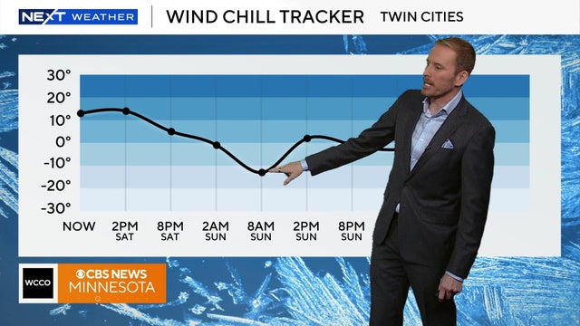
Temperatures will remain in the teens on Saturday, but the wild chill will make it feel closer to the single digits.

Temperatures will drop to the teens in Minnesota on Friday night following a snow system in the Twin Cities that impacted Friday morning's commute.
After the coldest morning Twin Cities residents have felt since mid-February, temperatures gradually warm through Thursday afternoon and evening.
After a stretch of lackluster winters, there are quite a few Minnesotans excited about the cold and snowy weather we're seeing.
On Monday evening, the first wave of a two-part storm arrives, bringing a few showers across southern Minnesota. Round two arrives Tuesday morning as rain for southern and central Minnesota and snow up north.

After a #Top10WxDay closed out the weekend in the Twin Cities, things will start to feel more seasonable at the start of the workweek.
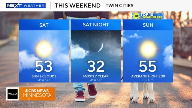
Weekend temps will be above average with highs in the 50s. Cold weather by Thanksgiving.

High pressure overhead will finally bring lots of sunshine to the Twin Cities to wrap up the work week.

Tailgaters at the Vikings-Bears game can expect upper 30s, but it is expected to be in the 40s by midday.

After record breaking heat on Friday, an overnight cold front has brought the temps down to the 50s for the metro area and high 30s to low 40s for other parts of the state.

After a stunning northern lights show Tuesday night, Minnesotans will get another chance to spot them on Wednesday.
As winds pick up Sunday, feels-like temperatures stay in the teens all day after starting in single digits across greater Minnesota.

Dock 6 Pottery in St. Anthony, Minnesota, continues to evolve since it first opened in 1995. It's a classroom, an art gallery and a fun spot to try your hand at something new.

A passing clipper system will reinforce the cold and even bring some snow chances for southern Minnesota on Saturday morning.