Heavy snowfall blankets western Pennsylvania and the Pittsburgh region
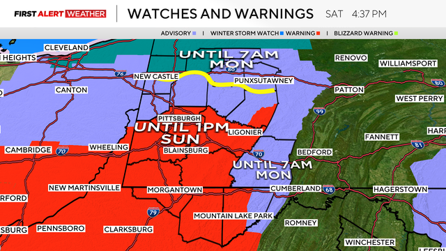
A Winter Storm Warning went into effect at 1 p.m. on Saturday afternoon for counties south of Allegheny County, and a Winter Weather Advisory was put into effect for Allegheny County and others to the north.
National Weather Service issues Winter Storm Warning
Earlier this week, the National Weather Service issued a Winter Storm Warning for parts of the Pittsburgh area along and south of I-70 for today and Sunday due to what they described as "a band of heavier snow."
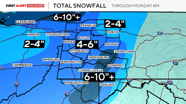
As of Friday evening, nearly all of the Pittsburgh area is expected to see between two and four inches of snow.
In Pittsburgh, the estimate is 3-5 inches and 5-10 for the ridges.
Snow will be coupled with frigid temperatures
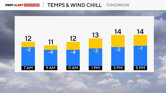
As the snow tapers off around midnight Sunday morning, it will remain scattered, but cold air will follow, leaving the low temperatures in the single digits, and the wind chill below zero as gusts could reach up to 15-20mph.
Road crews prepare for winter storm
Crews across western Pennsylvania say that they're prepared for the impending snowfall.
In Allegheny County, there are two dozen trucks and more than 9,000 tons of salt at the ready.
Even with the preparations, they're asking those who don't need to go out to stay off the roads in order to give them the space to clear them.
Several closings and delays issued for Monday
Dozens of schools and organizations in the Pittsburgh area have issued delays or adjusted plans on Monday as potentially icy road conditions and bitterly cold temperatures take over the region.
Highs on Monday are predicted to be at or near 20 degrees. Because of the cold temperatures, CitiParks and the city of Pittsburgh will also be opening several heating centers.
A full list of closings and delays can be found here.
Pittsburgh-area drivers found ways to navigate snow-covered, slick roads
Road crews and residents in southern Allegheny County spent the morning clearing the roads and digging out.
The snow was supposed to hit areas south of Pittsburgh pretty hard, and by morning light, that prediction proved accurate.
Rodney Hayes took to the roads of North Strabane on Sunday morning with a positive outlook despite negative road conditions.
"I take it all in stride. We can't enjoy the summer if we don't have the cold," Hayes said.
Hayes filled up his vehicle before hitting the road. He, like many, got his early morning workout out one shovelful at a time.
"(I) did it this morning; it was my pre-workout," Hayes said with a laugh.
Curry Hollow Road proved to be its normal challenge. The same was for Route 51 in the South Hills.
"You just have to take your time and drive cautiously, don't be in a rush," said driver Doug Ecelberger.
Ecelberger was operating a four-wheel drive pickup truck, but knows and keeps the No. 1 rule for those driving four-wheel drive vehicles in snow.
"You can probably go, but you aren't going to stop," Ecelberger said.
In Washington County, major roads were on the way to getting cleared by sunrise, but back roads in places like Nottingham Township, Peters Township, South and North Strabane remained covered, frozen, and treacherous.
And while keeping all four wheels on the road was the aim, keeping your personal traction is equally important.
"Not slipping. You have to make sure you don't slip and fall. That can be ugly."
Small business owners in Westmoreland County weather the storm
Through the lens of a camera, Ligonier, Pennsylvania, on Sunday morning resembled a beautiful snow-covered town one might see in a Hallmark Christmas movie.
And while the Diamond and the surrounding borough were a picture that would make Currier and Ives proud, temperatures were in the teens, and the snow was piled up by the inch.
Andrew Carr, who lives above his shop, Celtic Culture, on East Main Street, says shoveling is a great way to get exercise, but he is not sure if he wants to keep doing it all season long.
"This winter is the first winter I thought, 'I really should get somebody to shove my sidewalk, but I haven't found them yet, so I am still working on that," Carr said.
And while others, like Carr, were out clearing roads and sidewalks to try and make some pathways for the day, across from Celtic Culture, at Tubmill Creek Provisions, co-owner John Goodish says that despite the weather, they opened at their usual time, right at 6 a.m.
But he says it was not without a bit of a winter odyssey.
"So last night, I had to go up to Somerset and pick up my night baker and bring her down here to bake," Goodish explained. "Then, this morning, I had to run down and pick up my day baker to bring her to work because part of the road where she comes from wasn't plowed, and I have a four-wheel drive, so it wasn't a problem. Then I had to take the night baker back home, and then I went and picked up our deli person, and then the latest was, I went and I picked up our dishwasher."
Goodish said he traveled all across the region without a single sip of coffee.
"I have had one cup of tea, that's it."
It would seem that many small business owners in Ligonier share a creed akin to the United States Postal Service. No matter the snow, nor the gloom of night, these folks will weather the weather as best they can.
Heating centers to open across Pittsburgh area on Monday
The city of Pittsburgh will activate five warming centers on Monday, as the region prepares for an Arctic blast, with forecasted high temperatures near 20 degrees. All heating centers will be open from 8 a.m. to 7 p.m.
Heating centers opening
Beechview Healthy Active Living Community Center
1555 Broadway Avenue
Pittsburgh, Pa. 15216
Greenfield Healthy Active Living Community Center
745 Greenfield Avenue
Pittsburgh, Pa. 15217
Homewood Healthy Active Living Community Center
7321 Frankstown Road
Pittsburgh, Pa. 15208
Sheraden Healthy Active Living Community Center
720 Sherwood Avenue
Pittsburgh, Pa. 15204
South Side Market House Healthy Active Living Community Center
12th & Bingham Streets
Pittsburgh, Pa. 15203
Road conditions from the KDKA-TV Mobile Weather Lab
The view of the roads from Westmoreland County
Looking like a scene straight from a Christmas movie, Ligonier Township was a winter wonderland on Sunday morning.
Chris DeRose gives us a look.
PennDOT lifts more speed limit restrictions
As roads begin to clear and the snow moves out, PennDOT is lifting more restrictions.
Just after 8 a.m., PennDOT announced that speed limit restrictions have been lifted on several roadways throughout Allegheny, Beaver, and Lawrence counties.
It includes all interstates as well as Route 28.
The posted speed limits are now the speed limit again.
Travelers can visit 511PA for the latest conditions.
PennDOT working to clear roads after storm
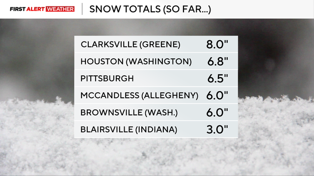
As Pittsburgh and the rest of western Pennsylvania woke up on Sunday morning, several inches of snow blanketed the area, with some seeing as much as eight inches.
During the KDKA-TV Sunday Morning News, PennDOT's Assistant District Executive of Maintenance, Lori Musto, joined the show to provide an update on their work overnight and into the morning.
With temperatures falling so rapidly, an extra challenge beyond just snow on the roads has emerged, so as usual, Musto stressed caution for those who may need to travel.
"Just slow down, give yourself extra time, be aware of changing conditions," Musto said. "The last storm we had a couple of weeks ago, temperatures hovered right around 32 degrees. The salt is a little more effective if the roads break; the ice breaks a little easier than it does when it's so cold, as it is today."
Musto also said that even with the cold, they're making progress but keeping an eye on the snow bands that could still move in this morning.
"We'll be out all day long, continuing to treat [the roads], daybreak does help, the little bit of traffic helps, but once again, if you don't have to be out, stay home, give us some time to get the roads cleaned up," she said.
You can watch the full interview below.
Snow showers to taper off on Sunday, frigid temperatures ahead
Most areas picked up 4–7 inches of snow yesterday and this morning, with some higher elevations seeing 8 inches or more. Snow showers are tapering off, but much colder air is moving in behind the system. Lows will drop into the single digits, with wind chills below zero and gusts around 15–20 mph.
The Winter Storm Warning expires at 1 p.m. A Winter Weather Advisory remains in effect for areas north of I-80 and the Laurel Highlands until 7 a.m. Monday. Lake-effect snow bands could bring an additional 2–4 inches in those areas.
Monday will remain cold, with lows in the teens and highs in the low 20s under mostly cloudy skies. Tuesday should be the last very cold morning for a while.
PennDOT lifts speed limit restrictions in southwest counties
PennDOT announced that the 45mph speed limit and right-lane only commercial vehicle restrictions for Interstate 70 and Interstate 79 in the Southwest Region.
That includes Greene, Washington, and Westmoreland counties.
The full list is below.
- I-79 from the PA Turnpike to I-76 to the West Virginia border.
- I-279, full length.
- I-376 from the PA Turnpike I-376 to I-76.
- I-579, full length.
Snow covers Washington County highways
KDKA's Chilekasi Adele, reporting from South Strabane Township, Washington County, shares a firsthand view of how much snow one of Washington County's most-traveled roads got on Saturday.
PennDOT reduces speed limits for several area roadways
As the snow began to fall on Saturday, PennDOT announced it had reduced speed limits for several major roadways across the Pittsburgh area, including Interstates 70, 79 and 376.
PennDOT is urging drivers to avoid unnecessary travel, but for those who must head out, speeds have been reduced to 45 mph on the following highways:
Allegheny County
- Interstates 79, 376 (Parkways East and West), 279 (Parkway North), and 579
- Route 28
Beaver County
- Interstate 376 (Beaver Valley Expressway)
Lawrence County
- Interstate 376
- Interstate 79
Washington and Westmoreland counties
- Interstate 70
Greene and Washington counties
- Interstate 79
Additional speed restrictions on interstates and expressways may be implemented as the storm progresses.
Although roadways will continue to be treated, PennDOT says its goal is to keep roads passable. Roadways will not be completely free of ice and snow, officials say.
PennDOT will continue to treat roadways throughout the storm until precipitation stops and roads are clear.
KDKA's Shelley Bortz reports from the Mobile Weather Lab
Areas south of Pittsburgh seeing heaviest of the snow
KDKA-TV Sunday Evening Forecast
Snow moved in right on schedule, and we are now moving into the part of the event where the heaviest rates are expected.
The steady, widespread snow will slowly taper from northwest to southeast between midnight through 4 a.m. Sunday with lingering flurries and snow showers. Lake-effect snow showers are expected to increase in coverage after sunrise and persist most of Sunday into Monday morning. Most of these will impact the I-80 to Route 422 corridors, but it is likely some of these bands—especially if we get a solid fetch off of Huron as well—will make it into the Pittsburgh metro area, leading to locally higher amounts and reduced visibility.
A lake-effect snow warning is in effect for Mercer and Venango counties to account for this.
See the updated Sunday forecast right here.
KDKA-TV Sunday Morning Forecast
Saturday morning is starting off quietly before widespread, impactful snow moves across the region.
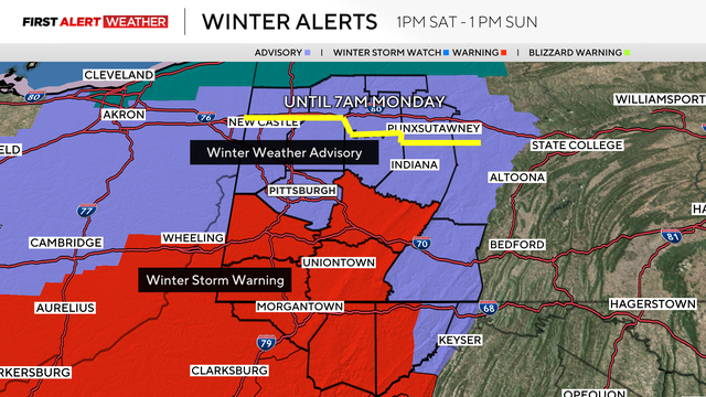
Winter Weather Advisories and Winter Storm Warnings start at 1 p.m. today and go until 1 p.m. Sunday. Areas north of I-80 are under a Winter Weather Advisory until 8 a.m. Monday with lake effect snow showers expected Sunday into early Monday behind the system.
After we deal with the snow on Saturday evening, temperatures will begin to fall with temperatures in the low teens and wind chill into the negatives on Sunday.
Get the full Sunday morning forecast right here.
Hey Ray: Which generation saw the most snowfall?
Every generation loves to say something to the effect of "back in my day, we got so much more snow!" Or, they also love the classic of having to "walk uphill both ways to school in the snow!"
Bragging about having to deal with the snow is nothing new, but let's explore that. Which generation in Pittsburgh actually saw the most snow?
I combed through the National Weather Service records when it comes to snow in Pittsburgh. Historically, the frequency of snowfalls of 12" or more is about once every 15 years.
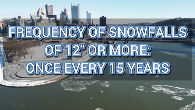
You can check out the full Hey Ray right here!
Maps estimate expected snowfall in Pittsburgh
A winter storm system is making its way to western Pennsylvania and is expected to bring significant snowfall to the region this weekend.
The National Weather Service issued a winter storm warning for parts of the Pittsburgh area along and south of Interstate 70 for Saturday into Sunday "due to a band of heavier snow."
Nearly all of the Pittsburgh area is expected to see between two and four inches of snow.
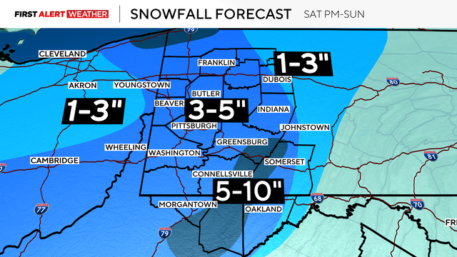
The current estimates forecast 3 to 5 inches of snow for much of the area, including Pittsburgh, and 5 to 10 inches for the ridges.