Showers will continue in the Philadelphia area as storms have weakened and moved out of the region

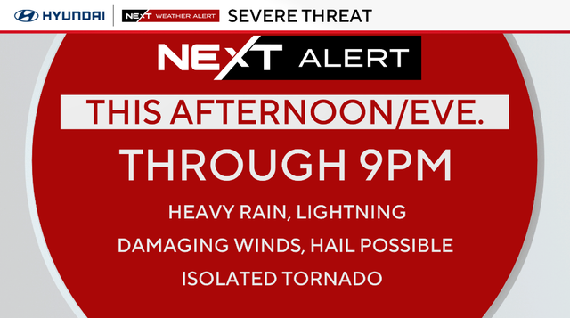
The Philadelphia area was hit with some stormy weather Saturday afternoon and evening, including potentially heavy rain, damaging winds and small chances of large hail.
A NEXT Weather Alert was issued for these storms moving from west to east.
The National Weather Service issued a severe thunderstorm watch until 8 p.m. for Kent and New Castle counties in Delaware; Atlantic, Burlington, Camden, Cumberland, Gloucester, Ocean and Salem counties in New Jersey.
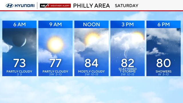
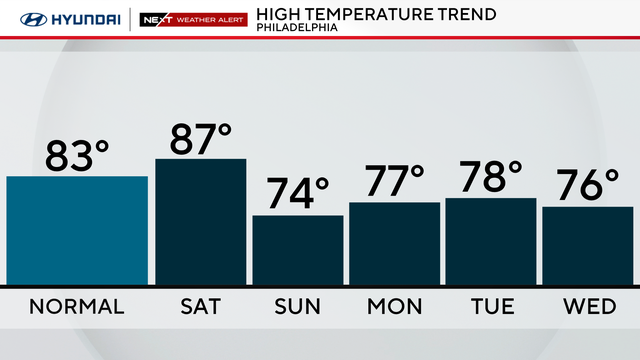
After a calm start, our weekend is feeling very much like summertime with warm and humid conditions. A southerly flow will send temperatures into the upper 80s this afternoon under a nice mix of sun and clouds. A cold front, however, approaching from the west will be the focus for developing showers and storms through the second half of the day.
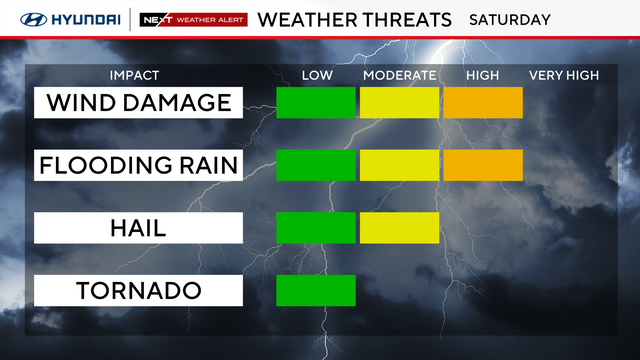
Most of the Philadelphia area is under a "Slight" (2 out of 5) risk for severe storms today. Areas closer to the shore have a lower, "Marginal" (1 out of 5) threat for storms as a lot of the stronger storms will weaken as they move east later this evening and the heat of the day begins to decrease.
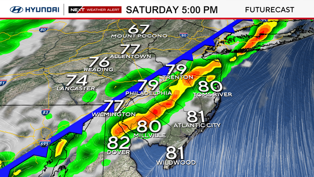
As the cold front advances east, a more organized line of rain and thunderstorms will develop into the Delaware Valley and the I-95 corridor. After 2 p.m., the threat for these storms becoming severe will increase and persist through around 7 p.m. to 9 p.m.
The primary concern with any of these stronger storms will be the threat of damaging winds and heavy rain. The intensity of the heavy rain may result in some areas of flash flooding with 1-3 inches of rain coming down in a relatively short period of time. There will also be the possibility of some hail and even an isolated tornado. That said, the greatest threat for severe weather will be from straight-line winds.
Flooding is possible in areas where there will be sustained heavy rainfall. The Storm Prediction Center says most of New Jersey north of Vineland, and the I-95 corridor in Pennsylvania and are under a Level 2 or "slight" risk of excessive rainfall.
Into the night, the cold front will push offshore, but showers will likely continue to push across the area, though the threat of severe weather will taper off by 9-10 p.m. Scattered showers will continue through Sunday morning as temperatures drop into the low 60s.
Thanks to a northwesterly flow behind the front, temperatures on Sunday morning will remain in the 60s with a decreasing chance of rain through midday. Skies will then gradually clear Sunday afternoon, allowing temperatures to jump into the low-middle 70s.
A nice pattern then sets up for early next week with high temperatures staying in the middle 70s and low temperatures in the middle 50s with partly cloudy skies through at least the middle of the week.
Here's your 7-day forecast:
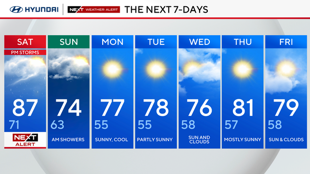
Saturday: NEXT Weather Alert for afternoon storms. High 87, Low 71.
Sunday: A.M. showers. High 74, Low 63.
Monday: Sunny, cool. High 77, Low 55.
Tuesday: Partly sunny. High 78, Low 55.
Wednesday: Sun and clouds. High 76, Low 58.
Thursday: Mostly sunny. High 81, Low 57.
Friday: Sun and clouds. High 79, Low 58.