Hurricane Melissa hits Jamaica as one of the strongest Atlantic storms. Maps show its forecast path.
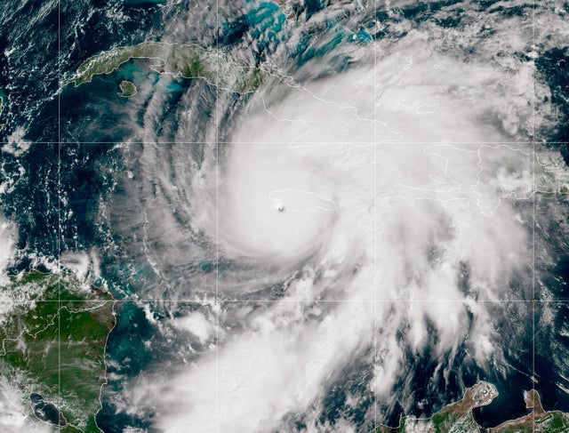
Hurricane Melissa hit Jamaica as a fierce Category 5 storm, making landfall Tuesday afternoon as one of the strongest hurricanes ever recorded in the Atlantic basin.
"This is an extremely dangerous and life-threatening situation," the Miami-based National Hurricane Center warned.
Melissa is expected to bring "catastrophic winds, flash flooding and storm surge," especially to the western part of the island, before moving on to Cuba and the Bahamas.
Melissa, the 13th named storm of the Atlantic season, isn't expected to have major impacts on the mainland United States, but it has turned into the strongest Atlantic system this season and is tied for the second-strongest on record in terms of wind speed.
Melissa's forecast and path
The storm made landfall along Jamaica's southwestern coast at around 1 p.m. ET on Tuesday, packing maximum sustained winds of 185 mph, the hurricane center said. Hurricanes reach Category 5 — the top of the Saffir-Simpson Hurricane Wind Scale — when their winds hit 157 mph.
Melissa's wind speeds were later clocked at 150 mph, making it a Category 4 hurricane, the hurricane center said in a 4 p.m. update. The storm was traveling north-northeast at 8 mph.
With the NHC's latest update, the storm was located about 10 miles south of Jamaica's Montego Bay, and about 215 miles southwest of Guantanamo, Cuba.
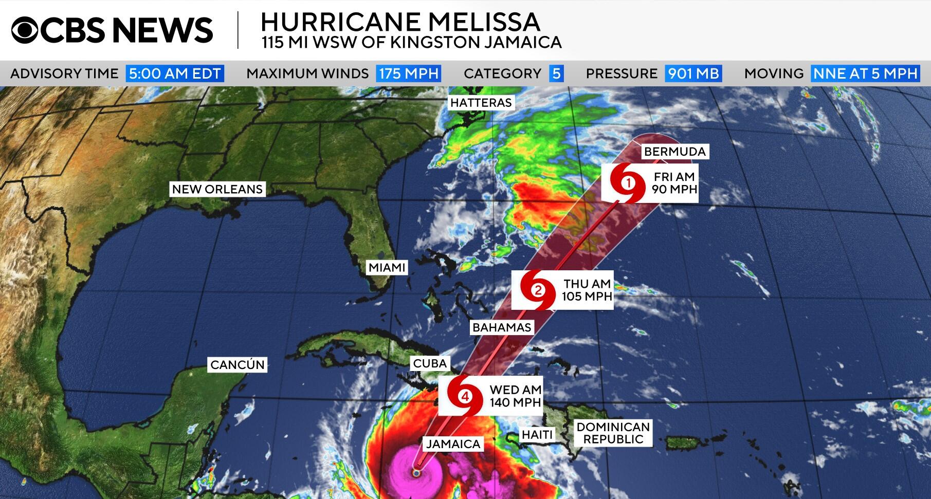
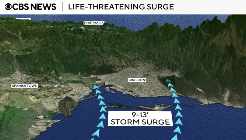
Peak storm surge accompanied by destructive waves is forecast to reach 9 to 13 feet above ground level in Jamaica, 8 to 12 feet in Cuba, 5 to 8 feet in the southeastern Bahamas, and 2 to 4 feet in normally dry ground of Turks and Caicos Islands.
The storm's extremely slow pace also raises the risk of destructive impacts, particularly in Jamaica.
"The devastation is going to be so profound because the storm is moving slowly," CBS News Philadelphia meteorologist Grant Gilmore said. "It's going to remain at a very slow pace as it traverses the island. ... All of the threats that a hurricane can unleash on an island, it's all going to happen in Jamaica."
"The island's terrain makes it even worse," CBS News Philadelphia meteorologist Andrew Kozak explained. "Jamaica's mountains force the air to rise, and that creates more rain."
The strongest previous hurricane to pound the island was Gilbert in 1988, which killed 45 people and caused more than $700 million in damage.
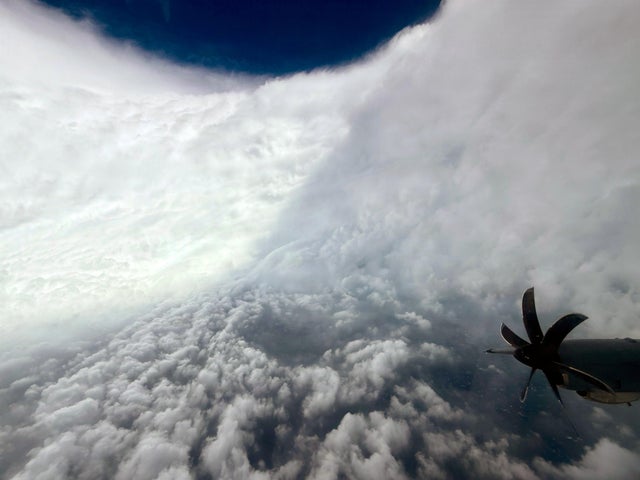
The crew of a U.S. Air Force 403rd Wing "Hurricane Hunters" flight ran into severe turbulence as it approached Melissa's eyewall on Monday and had to return to their base in Florida, but they did capture stunning images of the center of the storm. Another flight on Tuesday to gather data on the hurricane also had to turn back after hitting strong turbulence.
Hurricane advisories
A hurricane warning is in effect for Jamaica and the Cuban provinces of Granma, Santiago de Cuba, Guantanamo and Holguin, as well as the southeastern and central Bahamas.
A tropical storm warning is posted for Haiti, the Cuban province of Las Tunas and Turks and Caicos Islands.
The U.S. Naval Station Guantanamo Bay said it was moving "non-mission-essential" U.S. citizens off the island in groups ahead of severe weather from Melissa. About 1,000 U.S. military personnel have been evacuated.
Rainfall forecasts
Melissa is expected to bring 15 to 30 inches of rain to areas of Jamaica and 6 to 12 inches to southern Hispaniola (the island split into Haiti and the Dominican Republic) through Wednesday, with a total of 40 inches possible in some places, the hurricane center said.
"Catastrophic flash flooding and numerous landslides are likely," the center emphasized.
For eastern Cuba, total rainfall could reach 10 to 20 inches, with as much as 25 inches in some spots through Wednesday, which could result in "life-threatening and potentially catastrophic flash flooding with numerous landslides," the center added.
And total rainfall of 5 to 10 inches is expected Tuesday into Wednesday in the southeastern Bahamas, resulting in areas of flash flooding. Turks and Caicos Islands could see up to 4 inches of rain.
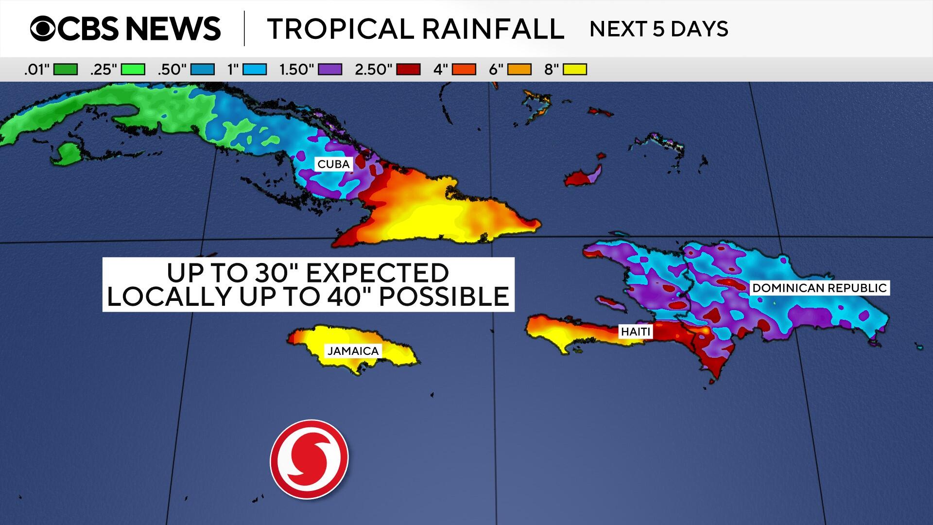
In the Bahamas, forecasters said, a total rainfall of 4 to 8 inches is expected Tuesday into Wednesday, resulting in areas of flash flooding. For Bermuda, heavy rain is expected Thursday night.
Climate change fueling the storm
Above-average Atlantic Ocean temperatures, made worse by climate change, helped Melissa rapidly intensify into a major hurricane, according to climate scientists.
"That part of the Atlantic is extremely warm right now — around 30 degrees Celsius (86 degrees Fahrenheit), which is 2 to 3 degrees Celsius above normal," Akshay Deoras, a meteorologist at the University of Reading in the U.K., told The Associated Press. "And it's not just the surface. The deeper layers of the ocean are also unusually warm, providing a vast reservoir of energy for the storm."
Stronger winds, heavier rainfall and higher sea level rise will make storm surge more intense.
Preliminary data from Climate Central, a nonprofit group of scientists monitoring the effects of climate change, suggests that climate change has increased Melissa's wind speed by 10 mph.
"Climate change is fundamentally changing our weather. It does not mean that every single tropical cyclone is going to go through rapid or super-rapid intensification. However, in our warmer world, it will continue to increase the likelihood of storms going through rapid and super-rapid intensification," Bernadette Woods Placky, chief meteorologist at Climate Central, told The AP.