Will Hurricane Melissa impact South Florida as it heads toward Jamaica, Cuba? See its projected path.
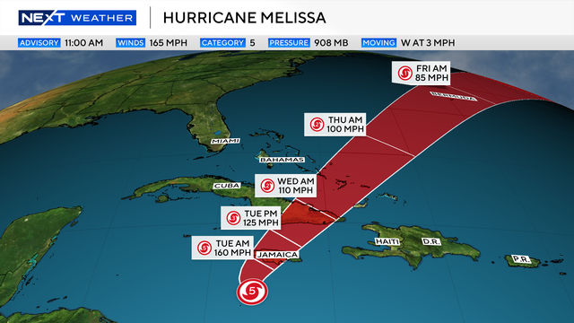
Hurricane Melissa has formed in the Caribbean, making it the 13th named storm in the Atlantic this year, the Miami-based National Hurricane Center said. Monday morning, it became a powerful Category 5 hurricane.
The NEXT Weather team at CBS Miami said no direct impacts are expected to South Florida at this time, but indirect impacts such as rip currents and hazardous sea conditions will be possible mid-to-late next week. The team will continue to monitor and provide regular updates throughout the week. As of now, the storm is not projected to hit any parts of the mainland U.S.
However, Melissa could be the most powerful hurricane ever to hit Jamaica, according to the NHC. It's forecast to bring "life-threatening and potentially catastrophic" flash flooding and landslides to the area and the southern parts of Haiti, the Dominican Republic and eastern Cuba over the next few days.
Where is Melissa?
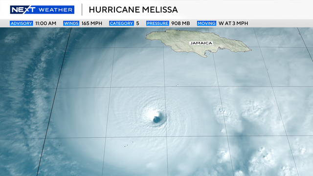
As of 11 a.m. Monday, Melissa's core was about 145 miles southwest of Kingston, Jamaica, and about 330 miles southwest of Guantanamo, Cuba, the NHC said.
Maximum sustained winds were 165 mph, with hurricane-force winds extending outward up to 30 miles from the hurricane's eye and tropical storm-force winds extending some 205 miles from the storm's center. It was moving west at just 3 mph.
Watches and warnings
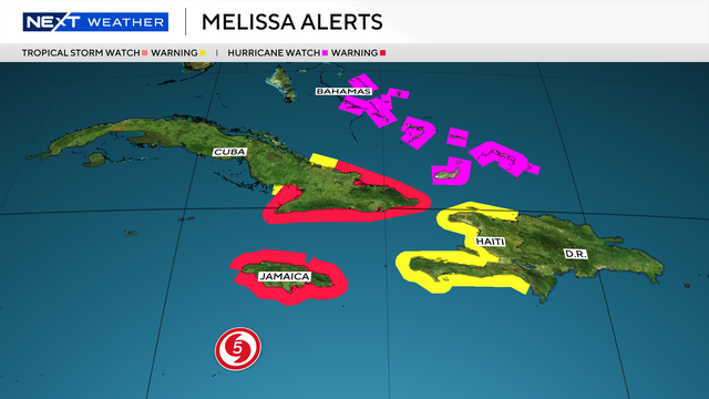
Jamaica is under a hurricane warning as Melissa strengthens and approaches the island. The NHC projects that the storm will make landfall in Kingston on early Tuesday morning as a Category 5 hurricane, and then in eastern Cuba later Tuesday or early Wednesday.
Cuba's government has also issued a hurricane warning for the Cuban provinces of Granma, Santiago de Cuba, Guantanamo and Holguin.
Southwestern Haiti is under both a hurricane watch and a tropical storm warning, with heavy rain and dangerous flooding expected. A tropical storm warning has also been issued for the Cuban province of Las Tunas.
What are the impacts?
Tropical storm conditions from Melissa are likely occurring in Jamaica, with hurricane conditions expected to begin by Monday.
Tropical storm conditions are expected to begin in Eastern Cuba by Tuesday afternoon, with Hurricane conditions expected to begin in the hurricane warning area by Tuesday evening.
Tropical storm conditions are ongoing in the warning area in Haiti. The potential for hurricane conditions in the watch area in Haiti has diminished for today, but there is still a possibility of hurricane conditions occurring there on Tuesday.
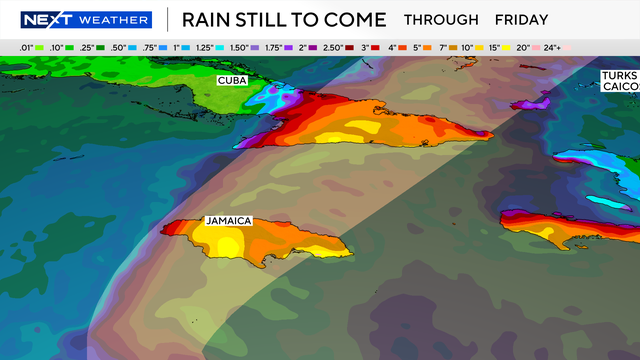
Melissa is expected to bring rainfall of 15 to 30 inches to portions of Jamaica and additional rainfall of 8 to 16 inches for southern Hispaniola through Wednesday, with local storm total maxima of 40 inches possible. Catastrophic flash flooding and numerous landslides are likely.
For eastern Cuba, storm total rainfall of 10 to 15 inches, with local amounts to 20 inches, is expected by Monday into Wednesday, resulting in life-threatening flash flooding and numerous landslides.
Over the Southeast Bahamas, total rainfall of 4 to 8 inches is expected Tuesday into Wednesday, resulting in areas of flash flooding.
Life-threatening storm surge is likely along the south coast of Jamaica late Monday through Tuesday morning. Peak storm surge heights could reach 9 to 13 feet above ground level, near and to the east of where the center of Melissa makes landfall. Large and destructive waves will accompany this storm surge.
There is a potential for significant storm surge along the southeast coast of Cuba late Tuesday or Wednesday. Peak storm surge heights could reach 6 to 9 feet above normal tide levels, near and to the east of where the center of Melissa makes landfall. Large and destructive waves will accompany this storm surge.
Swells generated by Melissa are expected to affect portions of Hispaniola, Jamaica, eastern Cuba, and the Cayman Islands during the next several days, and in the Bahamas and Bermuda later this week.
These swells are likely to cause life-threatening surf and rip current conditions.
By early next week, the storm will be near or over Eastern Cuba and the Bahamas. As the storm continues to move into the Atlantic, it will bring in cooler and drier air to South Florida.