Showers, thunderstorms bring localized flooding to South Florida ahead of fall cold front
A surge of deep tropical moisture has produced widespread showers and numerous thunderstorms across South Florida Friday, bringing localized flooding and pockets of heavy rain through the afternoon and early evening.
The CBS News Miami NEXT Weather team said rainfall totals of 1 to 3 inches are possible, with isolated areas seeing more than 4 inches, especially where multiple rounds of heavy rain occur. The National Weather Service continues to warn of flash flooding in low-lying and poorly drained areas.
While it has been a soggy day for much of the region, a shift in the weather pattern is on the way.
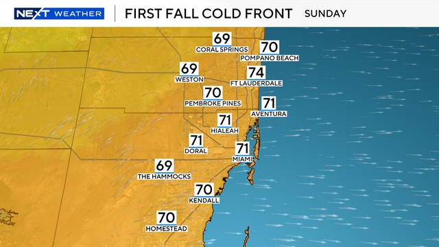
First fall cold front of the season coming to South Florida
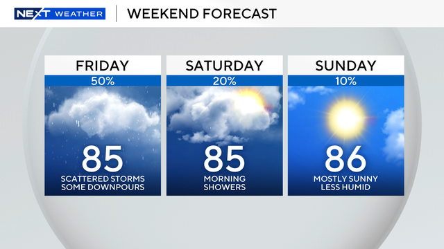
The season's first fall cold front will move in this weekend, ushering in drier air, lower humidity and cooler nighttime temperatures.
Saturday may still bring a few afternoon showers due to lingering moisture, but rain chances will drop sharply into next week, coinciding with the official end of the wet season.
A coastal flood advisory remains in effect for the Florida Keys through Saturday morning, with saltwater flooding expected in low-lying streets and lots, especially around high tide in the Lower and Middle Keys. Some storm drains may overflow, and boaters are advised to expect reduced clearance under fixed bridges. Motorists are urged to avoid driving through standing water, which likely contains a mix of saltwater.
By Sunday, South Florida will enjoy a brief taste of fall with morning lows in the low 70s along the coast and upper 60s inland, along with lower humidity and plenty of sunshine. The drier pattern is expected to persist into early next week as the dry season begins Wednesday, Oct. 15.