Watch CBS News

New England

joe-joyce.jpg

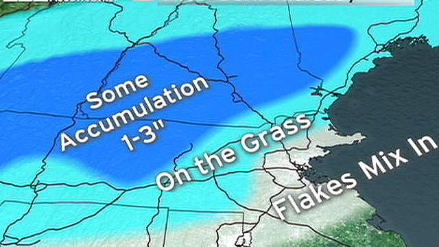
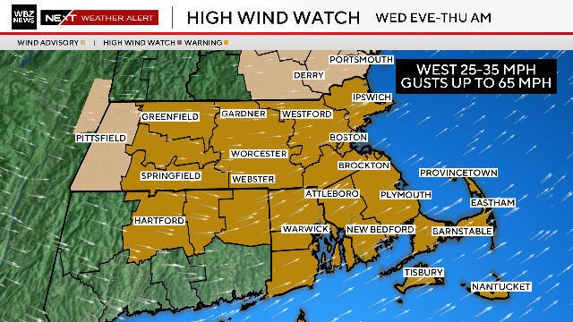
Another Short-Lived Cold Shot....

Temps are starting off in the 20's this morning with a west wind, and will have a tough time going much further today. Highs will climb into the Lwr 30's by midday into the afternoon...even climb into the Mid 30's for the south coast to the Cape. Temps will hold in the 20's across NH. Sunshine this morning will give way to some increasing cloudiness as clouds from the N & W will be pushing towards the coastal plain along with an Arctic front. Temps are below zero this morning across the Canadian border. This is the airmass which will be over us for the next 24-48 hours.

joe-joyce.jpg

Windswept Rainfall Tonight...Colder Air Returns...But For How Long?

Cool filtered sunshine this morning with increasing high altitude clouds will give way to mostly cloudy skies this afternoon and warming temperatures into the 40's. High pressure off the coast will wrap in warming SW winds...but the lack of sunshine will make it feel cooler. Keep a close eye on the radar today because we have quite a bit of rain just to our SW which is heading right to us for tonight. Clouds will thicken in advance of the rain this afternoon with showers arriving in western New England around sunset. Showers will be reaching the coast between 6-8 PM...

joe-joyce.jpg

The Weather Is Golden...Feel of Indian Summer To Return

The weekend weather is all about wind direction and airmass. Northerly winds are directing cool air from Canada over the region today. Winds are gusty on the Cape & islands and will die down during the afternoon. Temps at 850 are near 0 C, so cool northerly winds with this kind of airmass will help to keep temps mostly in the 40's to near 50 even with 100% of the sun. Ocean effect cloudiness will be effecting the Cape and the islands into the afternoon.

Show More
View CBS News In
CBS News App Open
Chrome Safari Continue